Discourses From the East
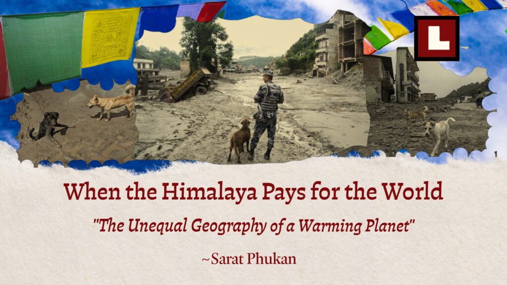

The unequal geography of a warming planet
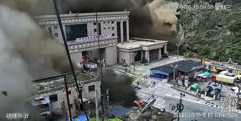
On 26 August 2026, a vast mass of rock and glacier ice broke away near Langtang Lirung on Nepal’s northern frontier. It fell nearly 1,400 metres before surging through valleys as water, mud and boulders. Settlements were buried, bridges disappeared, roads were cut off, and cropland vanished beneath sediment. By 21 September, more than 1,400 people had been confirmed dead, and thousands were still missing. Those figures could not describe the weeks that followed. Families searched for relatives, villages waited for help, and farmers found their fields under stones and mud. The flood passed within hours. The losses it left behind would shape lives for generations.
With steep slopes, fractured rocks and recurring earthquakes, the Himalaya produced landslides and catastrophic floods long before humans settled its valleys. After the Last Glacial Maximum, around 21,000 years ago, retreating glaciers left lakes whose sudden release could send immense floods down the rivers. Their traces remain in valley sediments. Even after the Holocene began about 11,700 years ago and the climate became comparatively stable, the mountains did not stop being dangerous. What has changed is that rapid warming is intensifying some of these hazards, while more people, roads, tourism facilities and hydropower projects now occupy the river valleys in their path. The 2015 earthquake may have weakened the rock mass, while glacier retreat and thawing ice within rock fractures may have further reduced the slope’s stability. The September 2026 World Weather Attribution assessment estimated that human-caused climate change made July and August temperatures in the area around the collapse about 1.5°C warmer. It did not assess whether this particular collapse would have occurred without that warming. The flood then swept through valleys inhabited for generations, where expanding development had placed more people and structures in its path. The Himalaya’s history explains the natural hazard; the changing climate and choices made along its rivers help explain the scale of the human catastrophe.
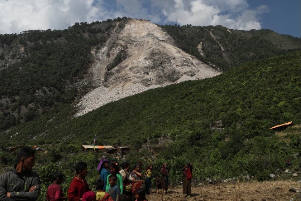
As Nepal counted its dead and faced reconstruction costs estimated at nearly US$5 billion, it requested US$20 million in emergency support from the Fund for responding to Loss and Damage. The request followed the August disaster and is separate from US$20 million approved under the Fund’s regular funding process for proposals Nepal had submitted earlier in 2026. The Fund was established through UN climate negotiations at COP27 and operationalised at COP28 to help particularly vulnerable developing countries meet economic and non-economic losses associated with climate change. Nepal accounts for less than 0.1 per cent of global greenhouse-gas emissions. Yet its people live in mountains where warming caused by global emissions is intensifying hazards they have faced for generations, even though Nepal has contributed only a tiny share of those emissions. They are being left to bear the costs of a crisis largely created elsewhere. Foreign Minister Shisir Khanal called on countries that have benefited from much larger and more polluting economies to accept shared responsibility for helping vulnerable countries such as Nepal. His appeal raises a political question for a neoliberal global economy that rewards carbon-intensive growth while leaving countries with little power over that economy to bear some of its gravest losses.
The heat we cannot simply turn off
Earth’s climate has never remained unchanged. Long before humans burned coal and oil, the planet passed through colder and warmer periods. At times, ice covered much of the Earth; at others, little permanent ice remained even near the poles. Earth has been far warmer than it is today at many times in its long history. What makes the present warming extraordinary is not simply the temperature reached, but the speed and cause of the change. Within only a few centuries, a single species has become a planetary geological force, altering the atmosphere, warming the oceans to great depth, melting ice, changing ecosystems and disrupting biogeochemical cycles across the Earth. Carbon dioxide released by burning fossil fuels and through land-use change slows the escape of heat from Earth, while agriculture adds other powerful greenhouse gases, especially methane and nitrous oxide. As the planet warms, the air holds more water vapour, retreating snow and ice expose darker surfaces that absorb more sunlight, and thawing frozen ground can release additional greenhouse gases. These changes add to the warming. The deeper problem is that the CO₂ already released will not quickly disappear. Even if human CO₂ emissions stopped tomorrow, much of the CO₂ already added to the atmosphere would remain for centuries, and a smaller fraction would persist for thousands of years. Global temperature would broadly stabilise near the level already reached; it would not quickly return to its earlier state. Himalayan glaciers, frozen slopes and mountain lakes would continue to respond to the warmth accumulated over decades. The conditions that favour such hazards could therefore persist for generations, even as some cryospheric changes continue for centuries after warming stabilises.
The geological past puts the scale of the present change into unsettling perspective. At the Last Glacial Maximum, around 21,000 years ago, atmospheric CO₂ was about 190 parts per million. It rose as the ice age ended, and the relatively stable Holocene climate gave farming and permanent settlements room to flourish. Humans may have begun altering the atmosphere long before industrialisation through forest clearing, rice cultivation and livestock, but the scale and speed changed with coal, then oil and gas. After the Second World War, mass production, private vehicles, air travel and expanding consumption accelerated emissions. In recent decades, the pursuit of cheaper production and ever-growing sales has moved many industries to places with lower labour and environmental costs, while much of the profit and consumption remains elsewhere. Pollution can be exported from a neighbourhood; its CO₂ cannot be kept out of the atmosphere. NOAA measured a global monthly mean of 428.55 ppm in April 2026, against about 280 ppm before industrialisation. An increase that would be immense on a geological timescale has taken place in a few human generations. Oceans, glaciers, ecosystems and societies are being forced to respond at a pace set by the economy rather than by the slower rhythms to which they adapted.
History offers a disturbing illustration of how human lives and the carbon cycle became entangled. After Europeans arrived in the Americas, epidemic disease, violence, forced labour and the destruction of Indigenous societies caused an estimated 56 million deaths by about 1600. This catastrophe became known as the Great Dying. As cultivated lands were abandoned, forests returned. Through photosynthesis, growing trees drew CO₂ from the air and stored its carbon in vegetation and soils. Koch and colleagues (2019) estimated that this regrowth stored about 7.4 billion tonnes of carbon, contributing to a measurable fall in atmospheric CO₂ and perhaps adding to the cooling associated with the Little Ice Age (AD 1450–1850). Today, more than eight billion people depend on land for food, while commercial farms, food-processing industries and their supply chains occupy vast areas. Settlements, cities, roads, mines and other industries continue to expand. Large areas of primary forest have already been lost, and the clearing continues. In Malaysia, tropical forest has been converted to oil-palm plantations; in the Brazilian Amazon, cattle pasture has been the principal use of cleared land. Protecting forests and allowing them to recover remain essential, but planting trees on the land available today cannot by itself return the atmosphere to an earlier state while forests are still being cleared and fossil fuels are still being burned. Planting trees in dry regions can also use up scarce water. China’s Three-North Shelterbelt is a vast afforestation programme intended partly to hold back the Gobi Desert. In some dry areas, the planted trees have depleted soil moisture. A separate 2025 study found that afforestation, grassland restoration and changes in cropland altered evapotranspiration and atmospheric moisture recycling across China, redistributing rainfall and water availability between regions. Water availability decreased in eastern and northwestern China but increased on the Tibetan Plateau. Large-scale afforestation can help remove carbon dioxide from the atmosphere, but it can also alter regional water cycles and, where water becomes scarcer, create environmental stress and hardship that planners may not have fully anticipated.
Around 4,200 years ago, prolonged droughts strained several ancient civilisations and may have contributed to profound social change. A weakening of the monsoon recorded in a stalagmite from Mawmluh Cave in Meghalaya marks the beginning of the Meghalayan Age, which extends from about 4,200 years ago to the present. Farther west, a stalagmite from Dharamjali Cave in the Himalaya records a 230-year interval of recurring summer and winter droughts between about 4.2 and 3.97 thousand years ago. The two records differ in detail, but both show how unreliable water became across parts of South Asia.
Ancient communities were often remarkably resilient because they could change not only where they lived but also how they lived. As rainfall became less dependable, some moved to regions with more reliable water, fertile land and a dependable climate, while others changed crops, farming strategies, and settlement patterns. The Indus communities provide a striking example. As aridity intensified, populations dispersed from some of the great urban centres into smaller settlements, while in some regions, agriculture shifted away from greater dependence on wheat and barley towards more drought-tolerant millets and a more diversified range of crops. Some communities also moved towards regions with more dependable rainfall. Their response was therefore not simply abandonment, but adaptation through mobility, crop choice and changes in the organisation of everyday life. As the urban system declined, populations increasingly dispersed into smaller settlements, with some communities moving eastward and southeast towards wetter regions, including the Ganga plains.
Such flexibility is harder for many communities today. Ancestral land, cultural identity and livelihoods can bind people deeply to particular landscapes, while national borders, private ownership, land prices and fixed infrastructure restrict the freedom to move when environmental conditions deteriorate. A family beside a Himalayan river may know that the slope above could collapse or the river could flood, yet have neither the money nor the land needed to move somewhere safer. Leaving may also mean surrendering fields, livelihood, community networks and a relationship with the land built over generations.
When warming meets the restless Himalaya
ICIMOD’s 2023 assessment found that glacier mass loss across the Hindu Kush Himalaya was about 65 per cent faster in 2010–2019 than in 2000–2009. At 1.5°C to 2°C of global warming, the region could lose roughly 30 to 50 per cent of its 2015 glacier volume by 2100. The consequences reach beyond the ice itself. Where a glacier once supported a valley wall, its retreat may leave broken rock exposed; thawing permafrost may weaken ice-filled fractures. Water entering cracks can raise pressure, while changing snow and rain add stress to slopes. These changes cannot tell us why a particular slope collapsed, but they can make slopes less stable. Once rock and ice begin to fall, moving debris can sweep up water, sediment, trees, and boulders, growing more destructive as it travels toward a settlement.
The 2021 Chamoli disaster in Uttarakhand showed how quickly this cascade can develop. About 27 million cubic metres of rock and glacier ice detached from the north face of Ronti Peak and rushed down the Ronti Gad, Rishiganga and Dhauliganga valleys. The flow destroyed bridges and severely damaged two hydropower projects; more than 200 people were killed or remained missing. Early reports described a glacial-lake outburst, but satellite images, seismic records and modelling showed that the event began as a rock-ice avalanche.
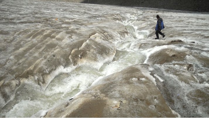
Retreating glaciers create another danger when meltwater collects behind ridges of loose rock and sediment left by the former ice. These lakes can grow rapidly even though their natural barriers are weak. When such a barrier breaks and releases the stored water, the event is called a glacial lake outburst flood, or GLOF. On 3 October 2023, about 14.7 million cubic metres of frozen moraine collapsed into South Lhonak Lake in Sikkim. The impact displaced the water, broke through the natural barrier and sent a destructive GLOF down the Teesta valley. Settlements and bridges were swept away, while the Teesta III hydropower dam was destroyed. This was not a single event in one place, but a chain of failures connecting thawing ground, a growing lake, a collapsing slope, a hydropower dam and communities far downstream.
Black carbon adds a more immediate regional pressure. Produced by internal combustion engines, coal and brick kilns, household fuels, agricultural stubble burning and open burning, this soot can travel to the mountains and darken snow and ice. The surface absorbs more sunlight and melts faster. Soot suspended in the air also absorbs heat and can alter precipitation. A 2025 modelling study of the Tibetan Plateau estimated that black carbon from South Asia increased glacier melt by 7.5 per cent by darkening the ice, while its effect on precipitation caused an additional 6.1 per cent loss of glacier mass. Unlike CO₂, it persists in the air for only a short time, so cutting emissions can bring relatively quick benefits. Doing so requires cleaner industry and transport alongside affordable cooking fuel, dependable electricity and waste services. Families with little choice of fuel should not have to pay to clean the air.
A collapse high in the mountains may be only the beginning. As rock, ice and water rush downstream, cut hillsides can add debris, construction waste can obstruct channels, and buildings in the flood path can put more people at risk. What happens along the river determines how far the disaster reaches and who must live with its consequences. Road cutting weakens hillsides, forest clearing removes natural protection, and construction waste dumped into gullies blocks water flow. Hotels, markets and settlements spread across floodplains, while dams, tunnels and powerhouses occupy narrow river valleys. Together, these conditions create a chain of risk in which a failure high in the mountains can move through slopes, glaciers, lakes, rivers and dams, gathering water, debris and destructive force before reaching communities far downstream.
Development in the path of disaster
People in mountain valleys need roads, hospitals, schools, communications and ways to earn a living, just as people elsewhere do. But decisions about major projects are often made far from the communities that will live with their consequences. A project appraisal may count the electricity from a dam, the businesses grown by a road or the income from tourism, while giving less attention to a spring disturbed by a tunnel, a forest that provides fodder or a field buried under construction waste. Structural designs based mainly on past rainfall, river discharge and historical flood levels may no longer capture the full range of hazards developing upstream as glaciers retreat, extreme rainfall changes, slopes destabilise, and glacial lakes expand. A project that appears safe when each hazard is considered separately may become vulnerable when several processes occur in sequence. A landslide, rock-ice avalanche or glacial lake outburst flood can enter a river or reservoir, displace large volumes of water, damage a dam or powerhouse, block a tunnel, overwhelm a spillway or force the sudden release of stored water downstream. Roads and hydropower projects can bring essential benefits to mountain communities, but those benefits cannot be assessed independently of the additional risks created when major infrastructure is placed in narrow valleys where water, sediment and debris are naturally concentrated. People living downstream may ultimately bear consequences never included in the project’s original benefit calculation.
History shows how such cascading failures can extend far beyond the place where they begin. At Vajont in Italy in 1963, the concrete dam itself survived, but a landslide into the reservoir displaced enough water to send a destructive wave over the structure and kill nearly 2,000 people downstream. In the 2026 Nepal disaster, multiple hydropower projects along the Trishuli were damaged, some far from the initial collapse. Planning must therefore consider how failures can spread through an entire river basin, what they could mean for communities downstream, and whether a site that appears technically and economically viable may still be too dangerous to develop.
Who gets the power and who carries the loss?
The market can price electricity, but a community forest, grazing ground or sacred river has no simple replacement value. Compensation often covers a titled plot or a damaged house while overlooking the food, fodder, fuelwood, medicinal plants and water that community land has provided for generations, as well as the livelihoods sustained by those resources. People who have lived from or cared for land for generations but do not legally own it are especially likely to be excluded from compensation. A project’s effects can continue long after construction ends. A hillside cut for a road may fail during a later monsoon, damaging houses or fields long after construction, yet those losses may fall outside the original compensation process. Downstream, water released from a dam can flood crops during the rainy season year after year, sometimes leaving fields covered with sediments. Families may receive little or no compensation for these repeated losses, even as each damaged harvest makes it harder to earn a living. A project boundary may also close the path a family once used to reach the forest for fodder or fuel. For the people living there, these are not separate mishaps. They are continuing changes to the land and river on which their lives depend.
This is the quiet ruthlessness of an economy organised around investment and ever-growing consumption. Distance makes it easier to ignore. Decisions travel upward to government offices, lenders and company boards, while water and debris travel downhill. Communities that question a project may be labelled opponents of progress when they ask to protect the land, forest, and river that sustain them. Hydropower can provide low-carbon electricity, but communities should not be made to bear avoidable harm in order to produce it. A fair project requires informed community consent, independent geological assessment, basin-wide hazard planning and advance warning of dam releases. Communities must also be compensated when project-related damage appears later or recurs years after construction. Governments must not allow developers to rush into construction before these requirements are met. Hydropower projects should share enduring benefits with the communities living beside them. The electricity bill records what the consumer pays. It says nothing about what people along the river gave up to produce that power.
When the damage becomes a debt
Financial support for rebuilding after a disaster should arrive quickly as grants, so vulnerable countries are not forced to borrow and fall deeper into debt. It must reach the families rebuilding homes, fields and livelihoods, including those living far from the capitals and institutions where funds are received, and decisions are made. In the weeks after the Langtang Lirung collapse, the deeper question was not simply why the mountain failed, but why so many people had little choice but to remain in places exposed to such hazards, why some had no means to move to safer ground, and why many would struggle to rebuild their lives afterwards. A disaster account can count a bridge or a powerhouse with some precision. It cannot as easily count lost harvests, access to a community forest, the loss of a livelihood, or the fear that returns every time heavy rain begins. These losses have a geography. So do the decisions that place people at risk, and the wealth generated by activities that are warming the planet.
Nepal’s appeal asks the world to recognise this geography as a question of justice. Much of the wealth generated through carbon-intensive development has accumulated far from the places now bearing some of its consequences. Electricity and tourism revenue may leave mountain valleys, while the families living beside their rivers remain exposed to the risks. Compensation alone is therefore not enough. Communities must also have the power to question unsafe projects, protect their land and livelihoods, and move to safer ground without losing their dignity, livelihoods and community when staying is no longer possible.
The mountain cannot be made still. But warming can be limited, and many of the human decisions that turn a natural hazard into a catastrophe can be changed. Responsibility therefore does not end with disaster relief. It also extends to those whose emissions have contributed most to warming, those with the greatest capacity to help, and those whose decisions determine how development proceeds in vulnerable mountain valleys.